T-Minus 2,000 Kilometers, And Counting

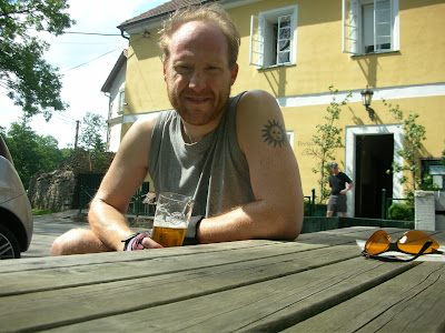
Podelco marks 1,000 kilometers with a cold pivo at his favorite watering hole in Okoř.
I'm one-third of the way to my goal, and on target.
I was off on Monday and went out for a solo ride to (where else!?) Okoř, my default destination.
The ride put me over 1,000 kilometers for the year so far. My goal for 2007 is 3,000 kilometers.
I celebrated the milestone with (what else!?) a cold Pilsner Urquell in Okoř (30 CZK, or about $1.40), and then it was back in the saddle for the ride home.
 It was a scorcher of a day, sunny and in the high 80s (around 30 Celsius). I was dragging a bit on the way home, but hitting the 1,000k mark kept me going.
Not a whole lot of interesting things to report about the ride itself, unfortunately.
I did see a picturesque pair of swans and their young (quick quiz: what's a baby swan called? answer below) paddling up the Vltava near Sedlec. And the rolling Czech countryside looked so nice from on the trail near Tuchoměřice that I just had a stop and drink it all in.
RIDE STATS
Length of ride: 44 kilometers
Average speed: 19.7 kph
Maximum speed: 51.1 kph
Time on the bike: 2.13.24
Distance ridden in 2007: 1,006 kilometers
Google Maps
I'm working on trying to add some maps of the trails I ride on this blog, using Google Maps. It's rather time-consuming, I've found, at least for a neophyte cartographer such as myself, but it's my intention to include maps of the most popular trails I write about on this blog.
If anyone has any tips, please pass them along.
I'm sure the first trail I add will be the path I take to Okoř.
Keep reading!

The lovely Czech countryside on a summer's day near Tuchoměřice.

A small lake in Okoř, just up from the Family Hotel Okor & Restaurant.
(Quiz Answer: Baby swans are called cygnets.)


Comments
I'm finding it all kinda tricky, to be honest! But I think it will be worth it if someone wants to actually bike some of these routes.
I also keep some Budwiser for the times when someone I don't care for drops by.
Take a look at this page...
http://maps.google.com/maps?q=http://trail.motionbased.com/trail/kml/episode.kml?episodePkValues=2259735
It was created from a handlebar mounted GPS/cyclocomputer (https://buy.garmin.com/shop/shop.do?cID=160&pID=6400). The data was uploaded to a PC then imported into Google Maps. It's really amazing what GPS can do.
I'll send you my e-mail, Tyler. I would love to see some more examples.